Drier and marginally cooler than average - the month being fairly flat and quiet with a lack of warm days and sunshine. Low pressure the more dominant feature.
July passed without ever getting going and overall was a quiet month, had few warm days and the lack of sun was fairly noticeable. Whilst pressure never fell too low and was indeed average for July, low pressure systems generally dominated and were never too far away from the UK. During a brief warmer period, 18th-23rd, the 19th gave one especially warm day, the warmest day of the year to date, but was followed on the 20th by a decent thunderstorm that lasted all morning.
The frequency of cloudy nights and thus high night-time minima was the main reason for the month's mean temperature being only marginally colder than average and indeed the mean minimum temperature was just warmer than average with the mean maximum showing a departure of just over 1°c below normal.
MSLP of 1014.6 Mb was +0.1 Mb above the local average for July, slightly surprising considering the near ever presence of low pressure systems, but despite the frequency of low pressure rainfall was never that heavy or prolonged.
Overall a mean minimum of 10.78°c and a mean maximum of 18.36°c saw the temperature 0.5°c below the 1981-2010 average and it was the warmest July since 2014 (the fifth warmest of the eight now recorded at this site). The highest maximum temperature recorded was 29.5°c (19th), the lowest minimum 4.4°c (6th).
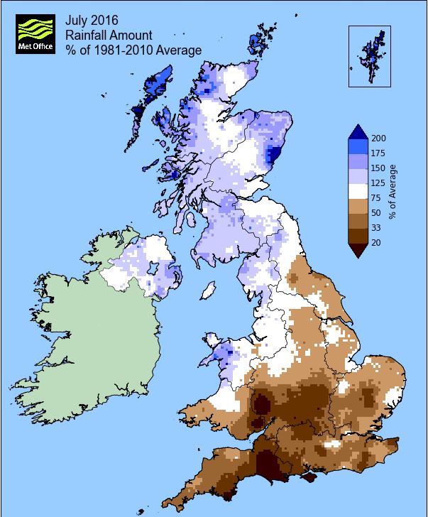
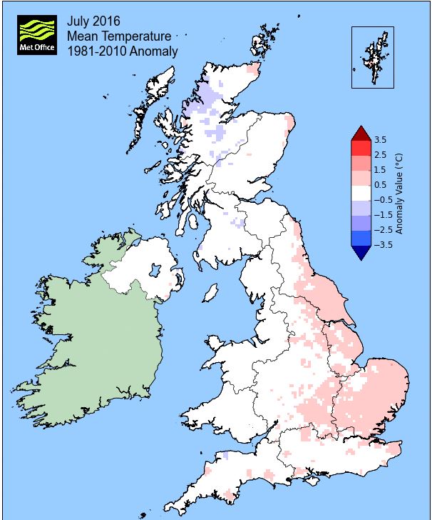
Rainfall of 66.5 mm (Crosby Ravensworth School 68.3 mm - CastleHowe Scar 58.2 mm and at Reagill, 73.2 mm) made it the driest July since 2014 (the 2nd driest of the ten now recorded at this site) and was 60.3% of average for 2007-15. Locally, rainfall percentages were just above normal with the Met'O stating that as a whole Cumbria was wetter than average. However, their map below could suggest that some area's had below average rainfall.
At the Met' Office site at Newton Rigg, 72.6 mm (103.4%) made it the driest July since 2015 and in a series back to 1900 there have been 53 wetter and 60 drier (with incomplete data for 3 years). In a series back to 1951 (with one year of missing data), a mean temperature of 14.85°c is the warmest since 2014 with 26 having been warmer, 3 having the same temperature and 35 colder in that time.
Figures from the Environment Agency’s rainfall sites were, (figure in brackets being the monthly average for 1961-90) ‘Data kindly provided by the Hydrometry and Telemetry team of the Environment Agency (Penrith)’:
Kirkby Thore (39.8 mm) faulty rain gauge
Brothers Water 184.6 mm (142 mm)
Nunwick Hall (65.8 mm) faulty rain gauge and
268.5 mm at Seathwaite Farm (Borrowdale - 204 mm [average for 1981-2010])
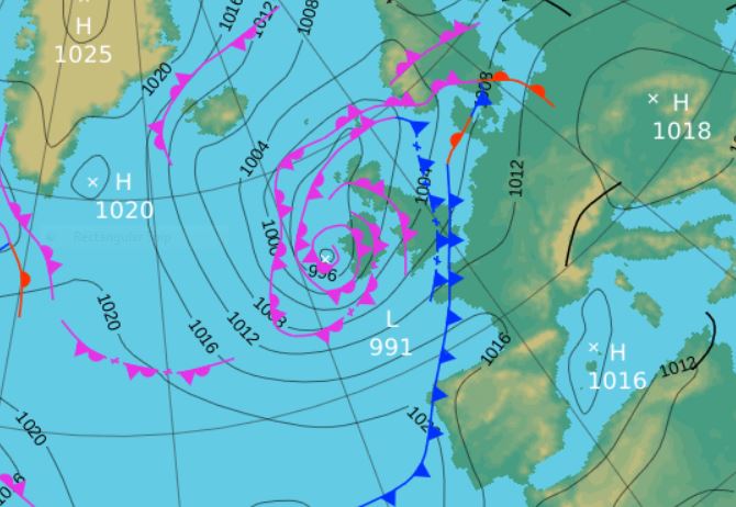
1st - 11th The month opened not as the height of summer, but somewhere more akin to the middle of autumn! Low pressure (LP) was generally dominant throughout the period and the month started with LP near Iceland drawing down W-WNW'ly winds; subsequently it was a little grey, cool and showery.
The 1st and 2nd saw temperatures struggling just above 14° with the 2nd feeling particularly cool in a fresh and brisk W'ly breeze and which would ultimately be a month's lowest maximum of just 14.2°c (57.6°f). Temperatures would very slowly recover into the range of 16-18°, but which is still below the norm' for July. Under the cloudy skies night-time minima stayed above 10° and resulted in a narrow diurnal range of temperatures, although the 6th started with a month's low of 4.4°c (39.9°f) as high pressure (HP) to the SW briefly ridged north.
In this time rainfall totals were generally light, mainly falling in the form of showers and/or light rain with only the afternoon of the 4th seeing something slightly heavier as LP moved across the UK to our south.
Once that LP of the 4th had cleared and following a brief ridge of HP, it was back to the frontal systems arriving from off the Atlantic and after the 7-8th had seen temperatures marginally over 18°, it once again became that bit cooler. LP out in the Atlantic very slowly moved east over the next few days, but with its associated fronts ahead of it which saw the 9th with 10.4 mm become increasingly wet as the day progressed. The 10-11th saw the LP itself finally arrive, the 10th having 8.7 mm before the LP finally exited north-east.
12th - 14th Gradually HP then started to ridge in from the south-west and which had the affect of drawing down a NW'ly flow. Apart from a few showers during the morning of the 13th it became drier - but also cooler, by both day and night.
The 12th saw temperatures back down to 14.7°c in a brisk WNW'ly flow, but given a little sunshine the temperature will quickly respond at this time of year and there was just enough on the 14th for it to rise to 19.3°c. The three days had all seen cooler nights with the 14th dropping to 5.6°c.
15th - 17th That HP over the UK was then shunted away as fronts associated to LP south of Iceland moved south. After a somewhat grey, damp and murky day 15th, the cold front that moved south brought fresher and clearer conditions and in some sunshine it didn't feel too bad.
17th - 20th
Later on the 17th that cold front petered out and allowed the HP that had been off the SW tip of Cornwall to re-establish itself over the UK. This HP would slowly migrate NE just off the coast of Germany towards Denmark and as a result it all became a little HOT.
A very warm southerly airflow with its origins in Africa was drawn up with the 18th seeing a quick rise in temperatures to 23.2°c as the cloud finally cleared and the sun came out.
However, the hot day was the 19th. At 29.5°c (85.1°f) it is the second warmest day in my records and the sun shone all day. At 1000 hrs the temperature stood at 22.9°c, rose to that year's high and was still 22.5°c at 2200 hrs - far too hot and now the night would be awful.
Indeed it remained over 20° until 0400 hrs on the 20th and only dropped to 19.0° before starting to rise again. But now a cold front associated to LP west of Eire was moving east and moving into that very warm air - the outcome is nearly always electric!
The thunder started at 0730 hrs and would continue for the rest of the morning with some quite vivid lightning. At times the rain that accompanied the storm was heavy and at 1005 hrs one quite notable discharge of fork lightning and very loud thunder appeared to strike very nearby and ultimately the power went off.
However, the record for the highest minimum temperature would not be broken, currently 17.1°c, as in the hour prior to 1000 hrs (the time when the various temperatures are recorded) when the thunder really started to get going, the temperature plummeted by nearly 4°c to 17.0°c (62.6°f).
the feed of warm air that brought the years warmest day followed by the unsettled conditions that gave the thunderstorm.
21st - 23rd
Despite the proximity of LP to the UK the next few days managed to stay dry, with some sunny intervals and pleasantly warm at just over 20°c as we somehow tended to avoid any fronts associated to that LP.
24th - 31st
The period through to the end of the month was at best mixed both some sun and spells of rain and which also saw a general dip in day-time temperatures.
The 24th was dreary, although not particularly wet has finally an occlusion moved west-east and whilst inbetween fronts on the 25th, it was still cloudy with the odd spot of rain.
A new frontal system that was hung w-e across the Atlantic brought a spell moderate rain (9.4 mm) overnight 26-27th, clearing to variable cloud and sunny spells. It remained dreary, damp and dull as LP west of Eire slowly moved to SW Scotland and its associated fronts trundled over Cumbria.
A NW'ly flow was introduced on the 29th as that LP moved out into the North Sea and its associated cold front sank south. From mid morning dreary skies cleared and the rest of the day was fine and sunny and the temperature responded, rising to 21.0°c - prior to 2016 the 29th had been the only July day in my records that had failed to hit 20L.
The month ended inbetween fronts with HP trying to ridge in from the south and consequently the days had variable cloud and sunny intervals, but with a drop in temperature.
Rainfall totalled 66.5 mm for the month, with rain recorded on 18 days of which 14 were 'Wet days' (1.0mm +).
The Mean Temperature for the month was 14.57°c -- The Mean Max' was 18.36°c -- The Mean Min' 10.78°c.
We had 0 Air Frosts in the month (year 39) -- Grass frosts totalled 0 (year 83).
The 1 foot soil temp ranged from a low of 14.1°c on the 3rd to a high of 18.0°c on the 20th - 23rd -- with a monthly mean of 16.0°c
The 1 meter soil temp ranged from a low of 13.0°c on the 4-8th to a high of 14.7°c on the 25th -- with a monthly mean of 13.7°c
COMPARISONS:-
* July 2016 rainfall was 60.3% of the July average for 2008 - 2015
* July 2016 was 0.31°c colder than the July average for 2009 - 2015 and 0.5°c colder than the local long term average 1981-2010
* 2015 Jan - July TEMP 7.79°c -- RAIN 656.8 mm
* 2014 Jan - July TEMP 9.48°c -- RAIN 800.1 mm
* 2013 Jan - July TEMP' 7.59°c -- RAIN 513.6 mm
* 2012 Jan - July TEMP' 8.16°c -- RAIN 601.3 mm
* 2011 Jan - July TEMP' 8.58°c -- RAIN 668.9 mm
* 2010 Jan - July TEMP' 7.50°c -- RAIN 314.2 mm
* 2009 Jan - July TEMP' 8.67°c -- RAIN 650.7 mm
* 2008 Jan - July TEMP' -- RAIN 723.7 mm
This makes the Jan' to July period of 2016 0.14°c warmer than the average for 2009-15 and with 107.6% of average rainfall for 2008-15
JANUARY 2010
FEBRUARY 2010
MARCH 2010
APRIL 2010
MAY 2010
JUNE 2010
JULY 2010
AUGUST 2010
SEPTEMBER 2010
OCTOBER 2010
NOVEMBER 2010
DECEMBER 2010
JANUARY 2011
FEBRUARY 2011
MARCH 2011
APRIL 2011
MAY 2011
JUNE 2011
JULY 2011
AUGUST 2011
SEPTEMBER 2011
OCTOBER 2011
NOVEMBER 2011
DECEMBER 2011
JANUARY 2012
FEBRUARY 2012
MARCH 2012
APRIL 2012
MAY 2012
JUNE 2012
JULY 2012
AUGUST 2012
SEPTEMBER 2012
OCTOBER 2012
NOVEMBER 2012
DECEMBER 2012
SUMMER 2012
REVIEW OF 2012
JANUARY 2013
FEBRUARY 2013
MARCH 2013
APRIL 2013
MAY 2013
JUNE 2013
JULY 2013
AUGUST 2013
SEPTEMBER 2013
OCTOBER 2013
NOVEMBER 2013
DECEMBER 2013
REVIEW OF 2013
JANUARY 2014
FEBRUARY 2014
MARCH 2014
APRIL 2014
MAY 2014
JUNE 2014
JULY 2014
AUGUST 2014
SEPTEMBER 2014
OCTOBER 2014
NOVEMBER 2014
DECEMBER 2014
WINTER 2014
REVIEW OF 2014
JANUARY 2015
FEBRUARY 2015
MARCH 2015
APRIL 2015
MAY 2015
JUNE 2015
JULY 2015
AUGUST 2015
SEPTEMBER 2015
OCTOBER 2015
NOVEMBER 2015
DECEMBER 2015
REVIEW OF 2015
JANUARY 2016
FEBRUARY 2016
MARCH 2016
APRIL 2016
MAY 2016
JUNE 2016
© Darren Rogers 2016
Want to comment on this site? email